


Charlotte County Fire Weather Analysis Graphs
Port Charlotte Fire Weather, Punta Gorda Fire Weather and the surrounding area
|
| Fire Weather for Port Charlotte |  |
|
|
Charlotte County Weather's CCWFSD is calculated from the peak recorded danger conditions from yesterday and today. This includes the high temp, lowest humidity, average high average wind speed and flammability of grass - this calculation is averaged against the current Fire Weather Index to reflect a current estimation of todays
Fire Spread Danger. The graphs below are calculated using data observations from recent weeks and months and offer a more accurate overview of fire weather conditions for the area. |
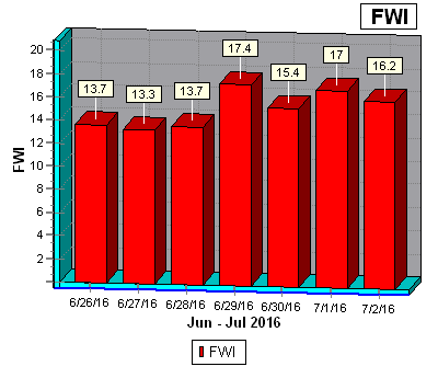 |
To interpret the system, the three fuel moisture codes and the three behaviour indices need to be understood. Each code and index is a numerical rating related to likely fire behaviour. The scales start at zero, and except for the Fine Fuel Moisture Code which has a maximum of 99, all are open-ended. Low ratings indicate high moisture content, and ratings rise as moisture content decreases. Ratings rise as fire weather potential becomes more severe. |
|
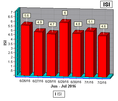 |
This indicates the rate fire will spread in its early stages. It is calculated from the FFMC rating and the wind factor. |
|
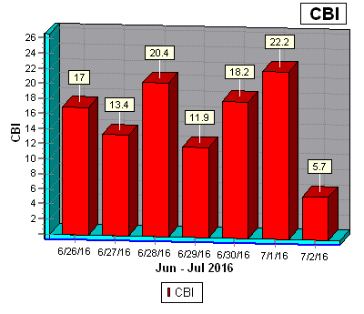 |
The Chandler Burning Index (CBI) uses the air temperature and relative humidity to calculate a numerical index of fire danger. That number is then equated to the Fire Danger severity of either extreme, very high, high, moderate, or low. It's based solely on weather conditions, with no adjustment for fuel moisture. |
|
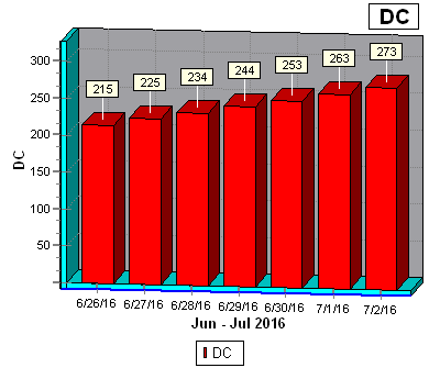 |
The DC is a numerical rating of the moisture content of deep, compact, organic layers. It is a useful indicator of seasonal drought and shows the likelihood of fire involving the deep duff layers and large logs. A long period of dry weather (the system uses 52 days) is needed to dry out these fuels and affect the Drought Code. A DC rating of 200 is high, and 300 or more is extreme indicating that fire will involve deep sub-surface and heavy fuels. Burning off should not be permitted when the DC rating is above 300. |
|
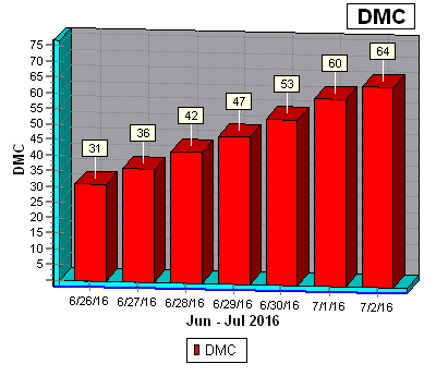 |
DMC is a numerical rating of the average moisture content of loosely compacted organic layers of moderate depth. The code indicates the depth that fire will burn in moderate duff layers and medium size woody material. Duff layers take longer than surface fuels to dry out but weather conditions over the past couple of weeks will significantly affect the DMC. The system applies a time lag of 12 days to calculate the DMC. A DMC rating of more than 30 is dry, and above 40 indicates that intensive burning will occur in the duff and medium fuels. |
|
 |
This index shows the amount of fuel available for combustion, indicating how the fire will develop after initial spread. It is calculated from the Duff Moisture Code and the Drought Code. |
|
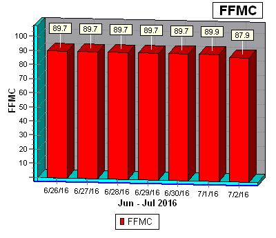 |
This is a numerical rating of the moisture content of surface litter and other cured fine fuels. It shows the relative ease of ignition and flammability of fine fuels. The moisture content of fine fuels is very sensitive to the weather. Even a day of rain, or of fine and windy weather, will significantly affect the FFMC rating. The system uses a time lag of two-thirds of a day to accurately measure the moisture content in fine fuels. The FFMC rating is on a scale of 0 to 99. Any figure above 70 is high, and above 90 is extreme. |
|
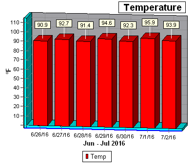 |
Charlotte County Weather uses the highest temperature of the day recorded by our weather station in the heart of Port Charlotte. All data is processed just prior to midnight in an effort to have the largest sampling of data possible for the day prior to final data point selection and calculations. |
|
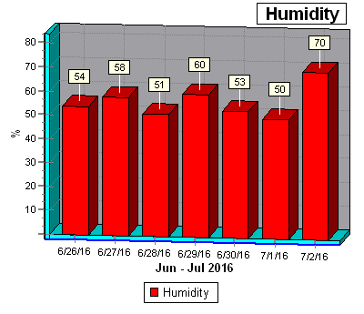 |
Charlotte County Weather uses the lowest humidity of the day as recoded by our weather station in the heart of Port Charlotte. All data is processed just prior to midnight in an effort to have the largest sampling of data possible for the day prior to final data point selection and calculations. |
|
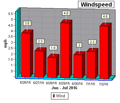 |
Charlotte County Weather uses the average wind speed for the entire day from the heart of Port Charlotte in our calculations. All data is processed just prior to midnight in an effort to have the largest sampling of data possible, prior to final data point selection and calculations. |
|
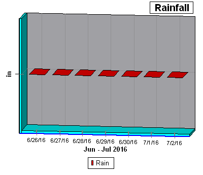 |
Total Rainfall mesurement for the previous 24 hours from the heart of Port Charlotte are utilized in several of the above calculations, for this reason all data is processed just prior to midnight in an effort to have the largest sampling of data possible for the day prior to final calculations. |
Charlotte County Weather